Pipeline Projects - Pipeline Information Management System (PIMS)

ipelines are the energy backbones of our today’s world. As existing pipelines do represent a huge monetary value but are also are aging, operators need a better understanding about their asset’s condition for proper and safe operation. The better the technical documentation the better is the basis for integrity management efforts with the goal to extent a pipelines lifetime and optimize its operations.
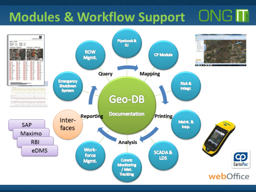
As pipelines are linear events plus all its supportive assets, a geo-database is needed in order to store the location of the spatially distributed information in an effective way.
For not starting over and over again from scratch, we typically use the Pipeline Open Data Standard in order to store pipeline relevant data. To get the best benefit out of the PODS data model, we’ve spatially enabled PODS and registered all feature classes within an Esri ArcSDE geo-database and utilising WebOffice as the WEB GIS front-end.
A huge amount of information and data is collected and processed during the life cycle of a pipeline, which we distinguish as follows:
- Design
- Procurement, Construction
- Operation
- Decommissioning
During all these phases, information is created by significant expenses and time efforts by different disciplines, which must cope very closely to exchange relevant data for the projects benefit. These disciplines basically are (but not limited to):
- Engineering
- Maintenance / Inspection
- Right-of-Way Management
- Construction Monitoring
- NOC Support
- eDMS Linkage
- SCADA Linkage
- Land acquisition
- Geology
- Environment
- Archaeology
- Social / HSE
- etc.
For optimizing technical- and business workflows during design, construction and operation it is beneficial to the project that all involved parties share relevant information via a centralized geo-database. Of course it is very important to have users and their roles defined to grant read-write or read-only access to stored information and data. By using WebOffice it’s assured that latest available information is shared within the project participants, independent from their geographic location as we provide our modules via our web platform, which of course can be also secured by using data encryption for the data streams.
Our centralized data storage and data distribution approach by utilizing web technologies avoids typical problems and challenges like redundant data storage, poor quality of data, inefficient exchange of data, huge paper based archives, time losses in finding the right information, etc.
Typically our PIMS solutions are based on industries standard PODS data model but can also become customized to existing data models if available. The goal is to store information within a structured data warehouse to make it easily and efficient available to users.
All information is related to the route(s) by using Linear Referencing Systems (LRS), which ensures that all relevant events along a pipeline can become identified by its coordinates or by its chainage. As the length of a route is subject to changes (especially during design) we also support Linear Referencing over Time.
The benefit of WebOffice and PIMS is to provide information via a Map or via easy to use Forms to the user for supporting the users’ daily workflows and make information easily accessible.
Due to our generic solution approach we do also support UPDM, APR (ArcGIS Pipeline Referencing), PODS lite as well as already implemented proprietary data models.us!
Please drop us an e-mail in order to obtain more information about our solutions!
SEND YOUR INQURIES FOR DETAILED INFORMATION TO: pims@ong-it.com
We’re happy to answer all your questions – don’t hesitate to contact us!
Why ONG-IT
Our definitive goal is to add value to your business. We match our processes to fit your preferences, so you feel comfortable and secure.
- Customer-Oriented Approach
- Best Practices
- Stable Qualified Teams
- Convenient Locations
- Comprehensive Solution